
OkMap Desktop v15.4.1 (Jan 2021 latest update) Full version
RM2.88 RM 9.99 71%
Product Information
Warranty Period: No Warranty
Warranty Type: No Warranty
OkMap is an interactive software which allows you to work on your computer screen with web maps or digital maps that you have either bought or scanned. OkMap can also import vectorial data from the most common formats and DEM data relevant to height information. Through these maps, you can organize your paths by creating waypoints, routes and tracks on your computer monitor, and upload this data to your GPS. OkMap sets automatically altitude data and estimates travel times. Furthermore OkMap provides you also with autorouting and geocoding functions.Data collected by your GPS can be downloaded on your computer, stored and displayed on the maps. They can also be used to create different types of statistics. By connecting a GPS to your laptop, you can plot your position on maps in real-time. If you are connected to the network you can constantly send your position to a remote computer, or receive the position of your companions on your computer and display the related tracks on maps in real time.
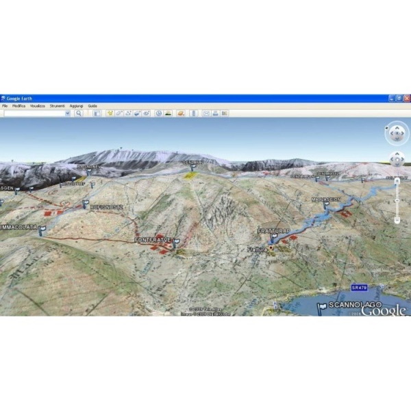
OkMap can also interface Google Maps and Google Earth. With Google Maps you can view maps and data of your interest. With Google Earth you can view your paths and your maps in 3D also.
OkMap include a feature to generate automatically compatible Garmin Custom Maps (KMZ format) and maps in OruxMaps format. This feature includes map tiling from and to different image file formats (including ECW map format). It's possible select KML extensions 2.2 (if GPS supports them), the JPEG quality, the image resizing, the KML transparency, the draw order, and so on. You can also select the tiles to generate in output. This feature support not north oriented maps also.
📌 KEY FEATURES:
✔ Calibration / display raster maps (over 30 image formats)
✔ Display vectorial maps
✔ Display hybrid maps (raster + vectorial data)
✔ Ability to open multiple maps simultaneously
✔ 9 cartographic projections of the most used
✔ Database with over 500 predefined projections by geographic area
✔ Database with over 300 datum
✔ Viewing 3D raster maps on Google Earth (for supported image formats)
✔ Map add-ons management (icons, comments)
✔ Vectorial data management (point, multipoint, line, polygon)
✔ GPX data management (waypoints, tracks, routes)
✔ Selecting multiple objects with the mouse
✔ Context menu (right mouse)
✔ Auto-info function
✔ Zoom, autofit functions
✔ Moving map function in 3 modes
✔ Customizing toolbar
✔ Showing yes / no toolbar
✔ Showing yes / no statusbar
✔ And so much more.....
💻 System Requirements:
✔ Supported OS: Windows 7/8/10
✔ Processor: Pentium IV or higher
✔ RAM: 1 GB RAM (2 GB recommended)
✔ Free Hard Disk Space: 200 MB or more

Shipping Information
| Zone | Weight | Delivery Fee (RM) |
|---|---|---|
| West Malaysia | First 3.00 kg | 6.00 |
| Extra 1.00 kg | 2.00 | |
| East Malaysia | First 0.50 kg | 14.30 |
| Extra 0.50 kg | 5.10 |